There are several questions on the examinations which test your ability on interpreting charts and standard aviation maps. For the purposes of the CPL balloon examinations you need to be familair with at least those symbols used on ERC-L and VTC. ERC-H and TAC are generally only used in IFR operations.
Airspace Boundaries
Airspace categories and their lateral and vertical limits are depicted on En-Route Chart-Low (ERC-L), En-Route Chart – High (ERC-H) , Terminal Area Chart (TAC) and Visual Terminal Chart (VTC). Each chart has a legend which gives specific information about the way information is depicted on the chart.
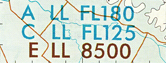 The lower limits of airspace are shown on all charts by indicating the airspace class and the lower limit. Where a piece of airspace commences at the surface the lower limit is shown as ‘SFC’. In areas where different classes of airspace are stacked vertically the labels are shown in layers.
Boundaries of Class A, C and D controlled airspace are shown on charts as a SOLID BLUE line. Class E controlled airspace is shown on charts as a SOLID BROWN line and should not be confused with the dashed brown flight information area frequency boundary. Military controlled airspace and restricted areas are shown using MAGENTA lines.
Flight Information Area Boundaries
![]() Boundaries for Flight Information Areas (FIA)are shown on VTC’s as SOLID GREEN lines. On ERC-L the G Airspace Frequency Boundaries are shown as SOLID GREEN lines. The FIS Frequency Information Box shows the provider of the flight information service, the frequency to be used and the location of the transmitter associated with the service. The frequencies shown in green should be used if operating in Class G airspace and the frequencies in brown if operating in Class E. In many situations these are the same but it is not always the case!
Boundaries for Flight Information Areas (FIA)are shown on VTC’s as SOLID GREEN lines. On ERC-L the G Airspace Frequency Boundaries are shown as SOLID GREEN lines. The FIS Frequency Information Box shows the provider of the flight information service, the frequency to be used and the location of the transmitter associated with the service. The frequencies shown in green should be used if operating in Class G airspace and the frequencies in brown if operating in Class E. In many situations these are the same but it is not always the case!
Aerodrome Information
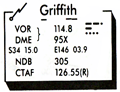
 On the VTC there is an aerodrome information box for each licenced aerodrome. The aerodrome information box contains the name of the aerodrome with its approved navigation aid identifier underlined, the types and frequencies of any navigation aids located at the aerodrome, the frequency to be used at the aerodrome and detail of control service (or lack of) provided at the site. If there are radar facilities at the aerodrome these will be listed as RADAR SSR at the bottom of the information box.The ABN W 6SEC in the example shown signifies that the areodrome has a Aerodrome BeacoN light White in colour that flashes every 6 SEConds
 On the ERC-L aerodrome information boxes are also shown but in a slightly different fomat. The lighning symbol in the top left indicates that VHF radio coverage with Air Traffic Services is available on the ground at the location.
Track Information
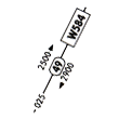
The ERC-L includes information on standard routes flown by aeroplanes and helicopters.These are shown as thin black lines adorned with lots of numbers. In the example (right), 025 is the magnetic track, 49 represents the distance along the sector in nautical miles, W584 is the route identifier which is recorded on the flight notification and 2500 and 2900 represent the lowest safe altitudes for the sector which in this example are different depending on the direction the the route os being flown. You will not be examined on this information in the balloon exams.
Topographical and Cultural
Included on the VTC is some sufficient topographical information for the chart to be used for visual navigation. The elevation of the land is shown as a hypsometric tint or background color on the chart. A legend for interpretation of the elevations represented by the various colours is provided on the chart. Each coloured area is bounded by a contour line which outlines the shape of the hill of valley at the particular level. Areas of water including rivers and lakes are shown with a pale blue background.
Included on the VTC are also some cultural items which can be used for navigation. Not all of the symbols used are included in the legend but they are generally similar to the symbols used on the 1:100,000 series topographical charts.You should be familiar with all of the symbols used on the VTC chart!

Planning Chart Australia (PCA)
Planning Chart Australia provides information regarding VHF and HF radio coverage, area forecast areas (ARFOR), AERIS transmitter locations and provides an overlay showing the World Aeronautical Chart (WAC) Series map coverage throughout Australia.
Pale mauve shaded areas have VHF radio coverage at 5,000 feet, dark mauve shaded areas have VHF radio coverage at 10,000 feet. HF radio coverage areas are bounded by the RED DASHED lines with HF frequencies to be used in the area shown in bold red.
Area Forecast Areas (ARFOR) are bounded by SOLID PINK lines with the ARFOR area number shown in a red circle.
Aeris transmitter locations and frequencies are shown with a green star.
The back of the PCA also has a list of more then 700 aerodromes, sorted alphabetically by name showing the four letter ICAO identifier of the location and the ARFOR area in which the aerodrome is located.
Exercises
Back to Pilot Exam Help Index
Technical data content credited to Mr Steve Griffin